
Invisalign in Palms, CA
With Invisalign, you may be able to get the smile you want in 6 months to a year.
First-Time Patient?
Consultation, Exam, X-Rays, and Regular Cleaning for only $250!
Online Booking
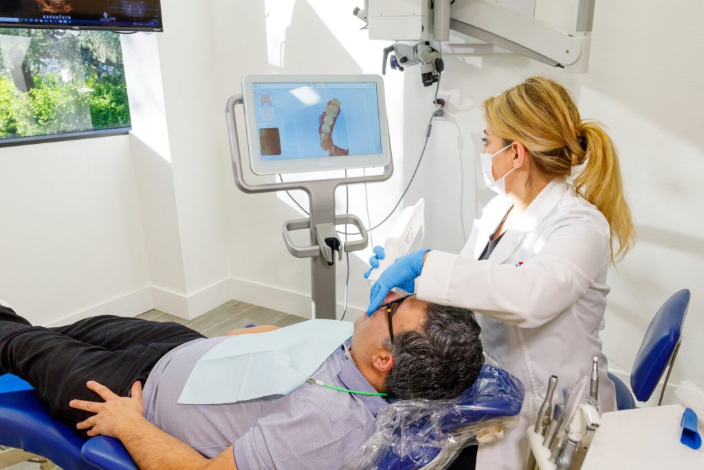
Invisalign Provider in Palms, CA
Clear aligners are not only almost undetectable but also extremely effective. With Invisalign, you may be able to get the smile you want in 6 months to a year. Our goal is to help every patient achieve stunning and healthy smiles through a comprehensive approach.
While traditional braces use harsh metal brackets, Invisalign is a gentler BPA-free plastic that causes less stress to your body. As a result, Invisalign is a less invasive and healthier way to straighten teeth.
With Invisalign, you can gradually straighten your teeth without sacrificing your favorite foods. While metal braces require patients to avoid hard candies and sticky foods, clear plastic aligners are detachable for meals, so you can eat whatever you want. In addition, because they are detachable, there is no fussy maintenance – just brush and floss as usual!
If you’re interested in straightening your teeth with clear aligners, call us at 818-766-7776.
Why Choose Invisalign over Braces?
- Clear aligners straighten your teeth without bulky metal brackets and wires.
- You can enjoy your favorite foods by taking out the aligners to eat.
- Clear aligners reduce the risk of awkward stains.
- You don’t have to add to or change your oral hygiene routine.
- Clear plastic aligners are more comfortable than traditional metal braces.
- Invisalign clear aligners are easy to clean.
- Invisalign plastic aligners are highly durable.
The clear aligner Treatment Process
Your clear aligners specialist will start the process by making a mold of your teeth. Clear aligners fit the specific shape and arrangement of your teeth for comfort.
Once a treatment plan is established, you will be given several aligners. Then, every ten days to 2 weeks, you will change one tray for the next, slowly moving your teeth to achieve the desired alignment.
How Long Does the Invisalign Treatment Last?
Although a clear aligner treatment requires less time than traditional metal braces, the length of time will depend on your situation. Most clear aligner treatments can straighten your teeth within a year; however, your Invisalign in Palms, CA, will be able to give you an exact time frame.
One of the main reasons Invisalign treatment requires less time than traditional braces is because patients don’t have to schedule frequent visits to their dentist’s office.
Traditional metal braces require patients to visit their dentist every six weeks for wire adjustments. With the Invisalign treatment, patients receive multiple clear aligners to switch out every couple of weeks without scheduling numerous appointments.
How to maintain Your Clear Braces
Your Invisalign provider in Palms, CA, will give you specific instructions on caring for your clear aligners. At Rite Dentist, we recommend that patients rinse their aligners with warm water daily and brush with a toothbrush.
How Much Does Invisalign Cost?
The cost of an Invisalign treatment depends on different factors:
- The number of aligners you receive
- The severity of your teeth misalignment
- The location of your Invisalign provider
Generally, the cost of clear braces treatment ranges between $3,000 and $8,000. Most dental insurance policies will cover between $1500 and $2000 for orthodontic treatments, but patients should refer to their policy benefits to confirm the exact coverage.
At Rite Dentist, we want our patients to receive the dental and orthodontic care they need without worrying about breaking the bank. That’s why we work with multiple insurance carriers and discuss payment options with our patients to establish an affordable payment plan.
Who can get clear braces?
Patients with slight or moderately crooked teeth can qualify for an Invisalign treatment. More severe misalignments may benefit from other forms of treatment.
The best way to know if you are a candidate for Invisalign clear aligners is to set up a consultation with us. We’ll examine the alignment of your teeth and recommend the best treatment option for your specific situation.
A Holistic Approach to General Dentistry
At our dental practice, our goal is to help every patient achieve the smile of their dreams and attain peak oral health. In contrast to traditional dental offices, we exclusively use natural materials for our dental procedures.
We use naturally compatible materials made of natural substances to create various restoration and cosmetic dental treatments beneficial for your body and immune system.
As a leading Invisalign provider in Palms, CA, Rite Dentist delivers unmatched dental and orthodontic services. Call our office today at 818-766-7776 to book an appointment.
Useful information regarding Palms, CA
Palms (originally “The Palms”) is a community in the Westside region of Los Angeles, California, founded in 1886 and the oldest neighborhood annexed to the city, in 1915. The 1886 tract was marketed as an agricultural and vacation community. Today it is a primarily residential area, with many apartment buildings, ribbons of commercial zoning and a single-family residential area in its northwest corner. As of the 2000 census the population of Palms was 42,545.
In Spanish and Mexican days, the area that later became Palms was a part of the Rancho La Ballona, where in 1819 Agustín and Ygnacio Machado, along with Felipe Talamantes and his son, Tomás, acquired grazing rights to 14,000 acres (57 km) of land. It was thenceforth used as grazing land for cattle and sheep. According to Culver City History, a 2001 work by Julie Lugo Cerra, published for the Culver City Unified School District:
Agustin Machado died in 1865, the same year La Ballona School was constructed to serve all elementary-age children within the Ballona School District. In 1871, Ygnacio Saenz established a general store at the crossing which later became Washington Boulevard and Overland Avenue. (Three corners of that intersection are in Culver City and one is in Palms.) The store, which was also a way stop on the county road between Los Angeles and the ocean, also housed the area’s first post office.
By 1882, the county’s electoral district serving Palms was known as Ballona, with voting at La Ballona School.
Deke Keasbey, real estate investment specialist for Tierra Properties, has noted that:
La Ballona Valley was part of that land rush. In 1882, several Midwestern families chartered a reconditioned freight car and left their homes in Le Mars, Iowa, to settle in the valley. They held their first Sunday school in the old La Ballona School on Washington Boulevard, and in fall 1883 they organized a United Brethren Church with 11 members.
About that time the valley drew the attention of three speculators – Joseph Curtis, Edward H. Sweetser and C.J. Harrison. They paid $40,000 for 500 acres (2.0 km). They surveyed their land and cut it up, and then they sold it to the new arrivals. They planted 5,000 trees along eight miles (13 km) of graded streets. They named it The Palms, even though they had to bring in palm trees and plant them near the train station. Their first tract map was dated December 26, 1886, which is now considered the birth date of Palms. During this time, the Palms-Southern Pacific Railroad Depot was constructed, serving as one of only two depots between Los Angeles and Santa Monica. It was moved to the Heritage Square Museum in 1976.
The site was midway between Los Angeles and Santa Monica on the Los Angeles and Independence Railroad (now the E Line light rail line.). Before the massive urban growth engendered by the Los Angeles Aqueduct, Palms was located within a farming and ranching area.
The subdividers gave the United Brethren Church two lots and $200 in cash to get started. In 1887 the church building was completed, and in 1889 the parsonage was built. In 1908 the old chapel was moved to the rear of the lot and new sanctuary built. In 1916 the old parsonage sold and a new one built. Later a bungalow was added next door to be a Sunday school.
Although its exact location has been lost, contemporary sources indicate the existence of a Palms Villa, Palm Villa, or Villa Hotel at least from no later than 1890 through 1904. It may have stood on Tabor Street, which was known as Villa Avenue at the time.
The residential development of a vast area west of the Los Angeles city limits brought a pressure for annexation to the city. Particularly noted was, first, the construction by L.A. of a new outfall sewer that could serve the area and, second, plans by the city engineer for a flood control project for the La Cienega region. Agitation for annexation was begun by Palms residents, but the reach was extended all the way west to the then-separate city of Sawtelle limits so that municipality could be annexed later.
There were two annexation elections. Both were hard fought. The first, on April 28, 1914, was voted down, according to the Los Angeles Times, “because the people in the suburban territory are afraid of the municipal bond craze, of which the power scheme is the last straw, and the threatened burden of extra high taxation.” The vote was 387 in favor and 264 against; a two-thirds vote was needed, so the “yes” vote was shy by 47.
A new petition was almost immediately submitted, leaving out all the areas that had voted against annexation. Nevertheless, Harry Culver, the founder of Culver City, denounced the new plan as a gerrymander and opposed it. But The Times wrote:
On June 1, 1914, the annexation succeeded, by a 342–136 vote, and on May 4, 1915, Los Angeles voters approved the annexation of the Palms district, as well as that of the extensive San Fernando Valley. Both Palms and the Valley entered Los Angeles on May 22, 1915.
The Travelers’ Handbook to Southern California, published in 1904, stated that “The Palms” was “named from the number of large palms which dot the region for quite a distance near the Southern
Pacific depot” and that “The Los Angeles and Pacific road has built via The Palms and Ocean Park to Santa Monica, making its line a belt of sixteen miles or more on each lap.”
Over the decades following the turn of the 20th century, the definite article was dropped from the place name. By the 1920s, the name was simply “Palms” on local transit maps.
Palms has no official boundaries, but the “Mapping L.A.” reference guide of the Los Angeles Times measures it at 1.95 square miles and places it northwest of Culver City, south of Cheviot Hills and Beverlywood, southeast of Rancho Park, west of Mid-City and northeast of Mar Vista. The 1886 subdivision map filed with Los Angeles County showed Palms as bounded on the northeast by what would today be Manning Avenue.
When Palms was annexed to the city of Los Angeles in 1915, the bounds extended westward from Arlington Avenue on the southeast and about Rimpau Boulevard and Wilshire Boulevard on the northeast to Pico and Exposition Boulevards on the northwest. West of Overland Avenue wasn’t annexed until 1927.
The portion of Palms girded by Overland, Sepulveda, National, and Charnock Road was developed just before World War II as Westside Village. The City of Los Angeles has posted official neighborhood signs for Westside Village, and it has its own homeowners association: the Westside Village Homeowners Association.
The Palms Neighborhood Council boundaries were defined by the city to omit Westside Village (which had already been claimed by the Mar Vista Community Council) and the area north and east of National Boulevard, which went to the Westside Neighborhood Council. Petitions were passed in both districts for boundary adjustments.
As of the 2000 census the population of Palms was 42,545, and the city estimated its population at 45,475 in 2008. With a population density of 21,983 people per square mile it is one of the most densely populated neighborhoods in Los Angeles. Palms is one of the most diverse neighborhoods in Los Angeles. Residents were 38.3% white, 20.2% Asian, 12.2% African-American, 23.4% Latino, and 5.9% from other races. The median household income was $50,684, about average for the city.
Almost half the residents (45.9%) had a four-year degree, which was a high figure compared to the city as a whole. The percentage of residents aged 19 to 34 was among the county’s highest.
In ancestry, Mexican (13.1%) and Irish (4.3%) were the most common, with about 40.4% being foreign born (average for the city). Mexico (17.3%) and Korea (5.9%) were the most common foreign places of birth.
Until the early 1960s, most of Palms was single-family homes and small duplexes and triplexes, most of which were built in the Craftsman and Spanish Colonial styles that dominated Southern California in the first quarter of the 20th century. Under pressure to provide affordable housing, the city of Los Angeles rezoned most of the district for large multifamily dwellings. This resulted in most of Palms’ historic housing stock being razed and replaced with two-story (or larger) apartment buildings. Very few original houses remain, and many of those are on lots where additional housing units have been built on what were once backyards. Palms is now one of Los Angeles’ most densely populated neighborhoods. The goal of the rezoning plan to provide affordable housing proved to be successful, as the neighborhood is now home to one of the largest concentrations of relatively low-cost rental units in Western Los Angeles. As of 2020, the median sales prices of single family homes in adjacent neighborhoods are all upwards of $1 million, while in Palms apartments can be found for as little as $1500 a month.
The housing stock in Palms is now almost completely composed of apartment buildings, and 92% of the population there are renters. In 2000, rentals in the entire Palms neighborhood amounted to 87% of occupied dwellings, compared to 13% of owner-occupied units. The upscale Westside Village district contains the only significant remaining concentration of owner-occupied single-family homes. While the neighborhood was largely constructed by developer Fritz Burns in assembly-line style just before World War II; most of these houses have been expanded or demolished in the ensuing decades, and the neighborhood today consists of a varied assortment of architectural styles with little resemblance to the original planned community. Apartment buildings, including two UCLA family- and graduate-student housing complexes, line Westside Village’s major thoroughfares. Many Palms residents work in adjacent Culver City, which is home to many large office and industrial complexes but has a relatively low population density. Despite being nearly five time larger in land area than Palms, Culver City has a slightly smaller total population.
These were the ten neighborhoods or cities in Los Angeles County with the highest population densities, according to the 2000 census, with the population per square mile:
Palms is served by the 405 (San Diego) and the 10 (Santa Monica [Rosa Parks]) freeways.
Palms is served by the Metro E Line, reactivating Pacific Electric passenger service which had been in place from 1875 to 1953. Service restarted in 2012, with the western terminus located near the intersection of Venice and Robertson Boulevards. The line now runs between Downtown Los Angeles and Santa Monica, with a stop at the Palms station, which opened on May 20, 2016.
Palms is considerably more bicycle-friendly than many other urban neighborhoods in Los Angeles, and bicycling is very popular[citation needed] owing to the neighborhoods density, young population, and scarcity of parking[citation needed]. Venice Boulevard and Motor Avenue, the two primary commercial corridors in the neighborhood, both feature dedicated bicycle lanes. The construction of the Metro E Line was accompanied by a Class A bicycle trail running adjacent to the tracks along Exposition Boulevard, the Expo Bike Path, which allows for easy bicycle access to the Palms station as well as being popular for recreational use by cyclists and joggers. This path was controversial,[citation needed] however, because of a large gap (stretching from Palms Boulevard to Overland Avenue) in the promised route following the E Line to connect to Santa Monica and the Pacific Ocean.
Palms is served by LAnow a new on demand shared-ride service. Serve started in May 2019, users can reserve a ride through the LAnow smartphone app, online or by phone. Once reserved, users can meet the shuttle at the scheduled LAnow pick-up/drop-off point. Within the service area, pick-up/drop-off points are never more than a few blocks (1/4 mile) away.
Palms’ diversity is reflected in its landmarks. Religious sites include the complexes of the International Society for Krishna Consciousness on Watseka Avenue and the Iranian-American Muslim Association of North America (IMAN) on Motor Avenue.
Palms has many Indonesian, Indian and Pakistani restaurants and businesses. In addition, it is also one of the centers of the Brazilian community in Los Angeles, with a number of Brazilian-oriented restaurants and shops, and one nightclub.
In 1979 the original Chippendales erotic male dancing club at 3739 Overland Avenue at McCune Avenue was started by Bengali immigrant Steve Banerjee when he turned his nightclub-disco, Destiny II, into a venue for male strippers.
The area is host to an unusual museum, the Museum of Jurassic Technology, and a research institute, the Center for Land Use Interpretation. It has a legitimate theater, the Ivy Substation, which is now home to the Actors Gang, led by Tim Robbins. The Ivy Substation is within Media Park, which has been leased to Culver City on a long-term basis.
Palms is served by a Los Angeles city-certified neighborhood council, whose governing body is called the Representative Assembly.
The council was certified as part of the city government on December 14, 2004. Its founding president was Len Nguyen, who resigned shortly after his taking office to work for newly elected City Council Member Bill Rosendahl. Todd Robinson succeeded as the second president, but he resigned a few months later. In March 2006 Vice President Pauline Stout moved up to become president. She was succeeded by George Garrigues (2008–09), Dee Olomajeye (2009–12), Eli Lipmen (2012–14), Marisa Stewart (2014–16), Nick Greif (2016–2018) and Alison Regan (2018–2019).
All of the stakeholders in Palms are members of the neighborhood council. Stakeholders include not only those who live, work, or own property in the district but also a broader category of people who can claim affiliation through some other kind of activity on behalf of Palms organizations. Three from that category were elected in spring 2005 to the Representative Assembly, a 13-member governing body composed of officers chosen on a district-wide basis and representatives elected from local areas.
Over the last decade, the Palms Neighborhood Council (PNC) has worked to:
The Los Angeles Fire Department operates Station 43, which also serves portions of Rancho Park and Cheviot Hills.
Los Angeles Police Department operates the Pacific Community Police Station at 12312 Culver Boulevard.
The Los Angeles County Department of Health Services SPA 5 West Area Health Office serves Palms.
The United States Postal Service Palms Post Office is located at 3751 Motor Avenue.
Almost half of Palms residents aged 25 and older had earned a four-year degree by 2000, a high figure for both the city and the county. The percentages of residents of that age with a bachelor’s degree or a master’s degree were also considered high for the county.
The schools within Palms are as follows:
Alexander Hamilton High School (Los Angeles), LAUSD, 2955 S. Robertson Boulevard serves Palms as its public high school.
Palms Park and Palms Recreation Center are in Palms. The recreation center has an auditorium, barbecue pits, lighted outdoor basketball courts, a children’s play room, a community room, and picnic tables. The Palms Park Child Care Center is adjacent to the park. Preschool is offered for children ages 3–5. The center has an enclosed play area.
Woodbine Park is also located in Palms. It is a small pocket park with picnic tables, a basketball court, and a children’s play area. It is this park where rapper Snoop Dogg was alleged to have been involved in the shooting death of gang member Philip Woldemariam.
Claim Your New Patient Special: