
Invisalign in West Hills, CA
With Invisalign, you may be able to get the smile you want in 6 months to a year.
First-Time Patient?
Consultation, Exam, X-Rays, and Regular Cleaning for only $250!
Online Booking
Invisalign Provider in West Hills, CA
Clear aligners are not only virtually invisible but also amazingly successful. With Invisalign, you may be able to get the smile you want in 6 months to a year. Our goal is to help every patient achieve beautiful and healthy smiles through a comprehensive approach.
While traditional braces use rough metal brackets, Invisalign is a gentler BPA-free plastic that causes less stress to your body. As a result, Invisalign is a less invasive and safer way to straighten teeth.
With Invisalign, you can gradually straighten your teeth without giving up your favorite foods. While metal braces require patients to avoid hard candies and sticky foods, clear plastic aligners are detachable for meals, so you can eat whatever you want. In addition, because they are detachable, there is no troublesome maintenance – just brush and floss as usual!
If you’re interested in straightening your teeth with clear aligners, call us at 818-766-7776.
Why Choose Invisalign over Braces?
- Clear aligners straighten your teeth without bulky metal brackets and wires.
- You can enjoy your favorite foods by taking out the aligners to eat.
- Clear aligners reduce the risk of awkward stains.
- You don’t have to add to or change your oral hygiene routine.
- Clear plastic aligners are more comfortable than traditional metal braces.
- Invisalign clear aligners are easy to clean.
- Invisalign plastic aligners are highly durable.
The Invisalign Treatment Procedure
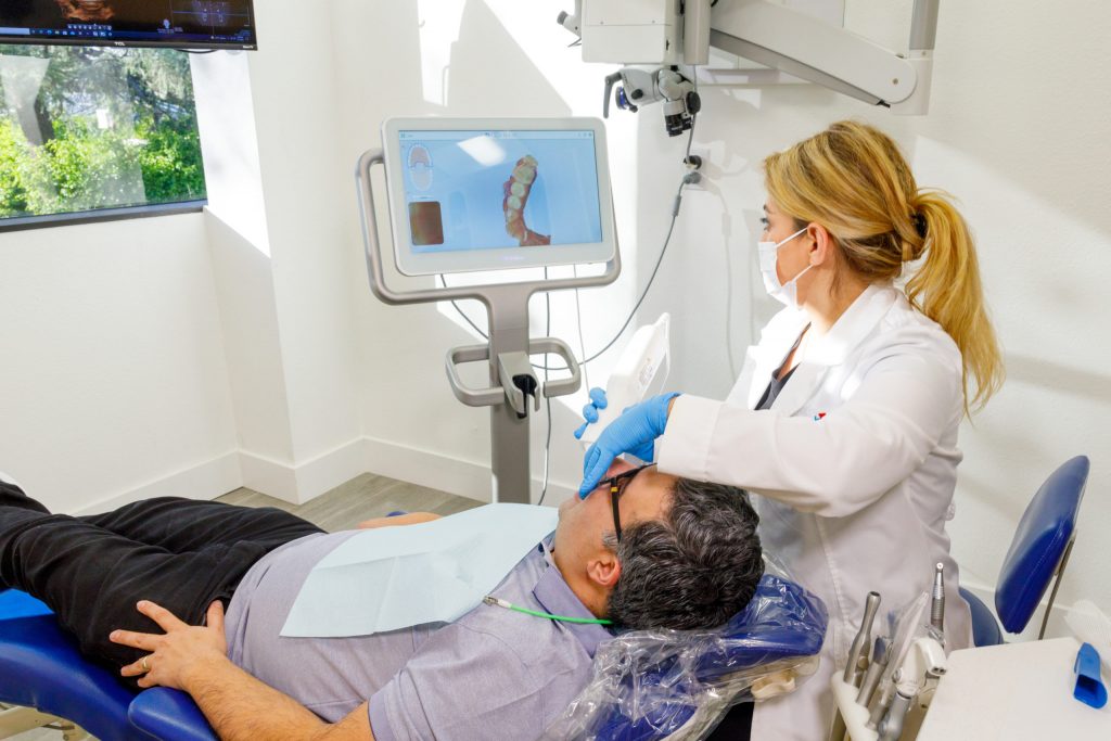
Your clear aligners specialist will start treatment by making a mold of your teeth. Clear aligners are designed to fit the unique shape and layout of your teeth for comfort.
Once the plan of treatment is established, you will receive several aligners. Then, approximately every ten days to 2 weeks, you will replace one aligner for the next, progressively adjusting your teeth to achieve the desired alignment.
How Long Does the Invisalign Treatment Last?
Although a clear aligner treatment requires less time than traditional metal braces, the length of time will depend on your situation. Most clear aligner treatments can straighten your teeth within a year; however, your Invisalign in West Hills, CA, will be able to give you an exact time frame.
One of the main reasons Invisalign treatment requires less time than traditional braces is because patients don’t have to schedule frequent visits to their dentist’s office.
Traditional metal braces require patients to visit their dentist every six weeks for wire adjustments. With the Invisalign treatment, patients receive multiple clear aligners to switch out every couple of weeks without scheduling numerous appointments.
How to maintain Your Clear Braces
Your Invisalign provider in West Hills, CA, will give you specific instructions on caring for your clear aligners. At Rite Dentist, we recommend that patients rinse their aligners with warm water daily and brush with a toothbrush.
How Much Does Invisalign Cost?
The cost of an Invisalign treatment depends on different factors:
- The number of aligners you receive
- The severity of your teeth misalignment
- The location of your Invisalign provider
Generally, the cost of Invisalign treatment ranges between $3000 and $8000. Most dental insurance policies will cover between $1,500 and $2,000 for orthodontic treatments, but patients should refer to their policy benefits to confirm the exact coverage.
At Rite Dentist, we want our patients to receive the dental and orthodontic care they need without worrying about breaking the bank. That’s why we work with multiple insurance carriers and discuss payment options with our patients to establish an affordable payment plan.
Who can get Invisalign?
Patients with minor or moderately crooked teeth can qualify for an Invisalign treatment. More severe misalignments may benefit from other forms of treatment.
The best way to know if you are a candidate for Invisalign clear aligners is to set up a consultation with us. We’ll examine the alignment of your teeth and recommend the best treatment option for your specific situation.
A Holistic Approach to General Dentistry
At our dental practice, our goal is to help every patient attain a beautiful smile of their dreams and achieve ideal oral health. In contrast to traditional dental offices, we only use natural materials for our dental procedures.
We employ biocompatible materials made of natural substances to create different reconstructive and cosmetic dental treatments beneficial for your body and immune system.
As a leading Invisalign provider in West Hills, CA, Rite Dentist offers unmatched dental and orthodontic services. Call our office today at 818-766-7776 to book an appointment.
Useful information regarding West Hills, CA
West Hills is a suburban / residential community in the western San Fernando Valley region of the City of Los Angeles, California. The percentage of residents aged 35 and older is among the highest in Los Angeles County.
The neighborhood was formerly the home of many Native American tribes, and during the early Spanish and Mexican era was part of the Mission San Fernando Rey de España. In the American era, West Hills was part of Owensmouth, which was renamed Canoga Park in 1930. West Hills was established in western Canoga Park and retained its present name in 1987.
Historic landmarks and many city parks are to be found within the community, as are commercial districts, a business district, and religious establishments. Two private high schools are among the 13 schools within West Hills.
West Hills (formerly joined with Canoga Park) is located in the western San Fernando Valley in Los Angeles County and about 45 minutes (depending on traffic) from downtown Los Angeles. It is off of U.S. 101 (the Ventura Freeway) via the Valley Circle Boulevard/Mullholland Highway off-ramp.
According to the 2008 Mapping L.A. project of the Los Angeles Times, West Hills is flanked on the north by the Chatsworth Reservoir, on the east by Canoga Park, on the south by Woodland Hills, on the southwest by Hidden Hills and on the west by Bell Canyon in Ventura County.
In 1987, Los Angeles recognized the following description of the boundaries of West Hills Neighborhood Council:
Bell and Dayton creeks in West Hills are several of the headwaters of the Los Angeles River that originate in the Northwest San Fernando Valley. The Los Angeles River itself begins at the confluence of Arroyo Calabasas (Calabasas Creek) and Bell Creek in Canoga Park. These and other small creeks supply stormwater and suburban runoff water to the Los Angeles River, and several are considered year-round creeks. Although the creeks are now channeled and run within concrete walls, they do form a significant urban wildlife landscape and contribute to the population of indigenous wildlife left within the San Fernando Valley.
Both Bell Creek and Dayton Creek in particular have received attention due to their headwaters origins inside the Santa Susana Field Laboratory in the Simi Hills. The SSFL is mandated for an environmental cleanup due to its uses as a testing center for rocket and missile engines, nuclear reactor research and fuel reprocessing, and high technology defense systems. It was also the site of a partial nuclear core meltdown in 1959. Prominent contaminants include radionuclides, VOCs-volatile organic compounds, Chromium, Lead, Benzene, and other components of rocket engine fuel and cleaning compounds.
This region experiences warm and dry summers with average temperatures peaking at 96 degree highs throughout August. West Hills has a climate similar to other locations in the west San Fernando Valley, such as nearby Woodland Hills with a long established weather station at Pierce College. According to the Köppen Climate Classification system, West Hills has a warm-summer Mediterranean climate, abbreviated “Csa” on climate maps.
As of the 2010 census, and according to the Los Angeles Almanac, there were 38,814 people and 10,626 households residing in West Hills. The ethnic-racial medley of the neighborhood was 78.89% White, 11.97% Asian, 0.05% Pacific Islander, 2.11% African American, 0.36% Native American, 2.80% from other races, and 3.82% from two or more races. 9.26% of the population were Hispanic of any race.
The Los Angeles Times reported that the 2000 U.S. census counted 30,814 residents in the 8.53-square-mile (22.1 km) West Hills neighborhood,—or 4,551 people per square mile, among the lowest population densities for the city. In 2008, the city estimated that the population had increased to 41,426.
In 2000, the median age for residents was 39, considered old for city and county neighborhoods; the percentages of residents aged 35 and older were among the county’s highest.
The neighborhood was considered “moderately diverse” ethnically within Los Angeles, with a high percentage of white residents. The breakdown was whites, 70.9%; Latinos, 11%; Asians, 11.3%; blacks, 2.5%; and others, 4.3%. Iran (13.8%) and the Philippines (8.4%) were the most common places of birth for the 22.7% of the residents who were born abroad—a low percentage for Los Angeles.
The median yearly household income in 2008 dollars was $103,008, considered high for the city and county. The percentage of households that earned $125,000 and up was high for Los Angeles County. Renters occupied 12.6% of the housing stock, and house and condominium-owners occupied 87.4%.
The percentages of married people were among the county’s highest. In 2000, there were 785 families headed by single parents, a low percentage for both the city and the county.
Eleven percent of the population were military veterans, a high rate for the city and the county, and the percentages of veterans who served during World War II or the Korean War were among the county’s highest.
The 1980 census showed 32,370 people living in the area that later became West Hills, of whom 92% were white, 7% Hispanic, 1% black, 4% Asian and 3% other. Families constituted 90% of the population, and 72% of the residents owned or were buying their own homes. Fifty-three percent had attended college.
The present day West Hills area was the homeland of Native Americans in the Tongva-Fernandeño and Chumash-Venturaño tribes, that lived in the Simi Hills and close to Bell Creek and other local tributaries to the Los Angeles River. Native American civilizations had inhabited the San Fernando Valley for an estimated 8,000 years. The village, Hu’wam, of the Chumash-Venturaños, was located at the base of Escorpión Peak (Castle Peak) near present-day Bell Canyon Park. It was a meeting and trading point for them with the Tongva-Fernandeño and Tataviam-Fernandeño people. A cave near Hu’wam, known as the Cave of Munits, is the believed home of a mythical Chumash shaman named Munits, who was killed by an eagle after murdering the son of a Chumash chief. Escorpión Peak is one of nine alignment points in the ancestral Chumash homelands, believed essential to maintaining the balance of the natural world.
From 1797 to 1846, the area (future West Hills) was part of Mission San Fernando Rey de España (Mission San Fernando). After Mexico won independence from Spain, it later became part of Rancho Ex-Mission San Fernando in Alta California. In 1845, a separate land grant for Rancho El Escorpión was issued by Governor Pío Pico to three Chumash people: Odón Eusebia, Urbano, and Urbano’s son Mañuel. It encompassed the land west of present-day Woodlake Avenue in West Hills, with its adobe ranch buildings (present 1840s—1960s) sited beside Bell Creek near present-day Bell Canyon Park.
California was admitted to the United States in 1850, with Spanish and Mexican land grants requiring a federal land patent to retain ownership. The United States Public Land Commission patented the Rancho to original grantees Odón Eusebia, Urbano, and Mañuel in 1876. In 1912 the Chumash heirs sold Rancho El Escorpión to George Platt. He established a dairy operation on renamed Platt Ranch variously called Ferndale, ‘escorpion,’ or Cloverdale Dairy. The Rancho El Escorpión-Platt Ranch was not incorporated into Los Angeles and its water system until 1958 and was left undeveloped until 1961.
West Hills was originally part of Owensmouth (founded 1912) and renamed Canoga Park (1931).
Under the leadership of Joel Schiffman, residents of a three-square-mile area in western Canoga Park began a petition campaign in 1987 to separate from the larger community and establish a neighborhood of their own to be called West Hills, the same name that a 303-home subdivision in a nearby unincorporated area had carried for years. The Los Angeles city district of 4,700 single-family homes and 35 businesses would be bounded by Roscoe Boulevard on the north, Woodlake Avenue, Sherman Way and Platt Avenue on the east, Victory Boulevard on the south and the county line on the west. Proponents said the change would give the area “political clout” and increase property values. The drive, which was opposed by the Canoga Park Chamber of Commerce, was partially financed by a real estate firm, whose owner, Lynn Garvanian, said the name change would “add 5% to the value of homes.” The campaign was quickly criticized as “snobby and greedy” by members of the Canoga Park Chamber of Commerce but defended by supporters who said it would allow the neighborhood to preserve its residential character. Petition leaders said they hoped a new name would separate the more affluent West Hills area from Canoga Park’s “fading factories, aging subdivisions and X-rated bars and theaters.”
As the petition drive expanded to include three more areas – two on the edge of the Chatsworth Reservoir and one on the western edge of Canoga Park – the Canoga Park Chamber of Commerce took an official stand against the separation, with president William Vietinghoff calling it “a source of division and disharmony . . . an extremely dangerous precedent for the whole San Fernando Valley.” Council member Hal Bernson, however, said he did not “look at it as a slam against Canoga Park – just as a group of people wanting identity.”
On January 16, 1987, Councilwoman Joy Picus accepted petitions representing 3,364, or 77% of the 4,333 households in the area within her councilmanic district, and she immediately said she would direct the city’s transportation department to put up boundary signs as the residents requested. Many of the latter expected the name change to add thousands of dollars of value to their properties. Two weeks later Picus added another two-mile-wide section of Canoga Park that gave West Hills the Fallbrook Mall and Platt Village shopping centers, along with several smaller retail strips and some older residential tracts built in flatland areas. This addition was denounced by Schiffman, who said it did “a lot to erode the community identity we sought.”
In what was called a “stampede,” other areas sought entry into West Hills, one homeowner on Santa Susana Place saying residents there wanted to “divorce ourselves from Canoga Park’s element.” Council member Hal Bernson agreed to add a square-mile area with 423 households bounded by Roscoe Boulevard on the south, Parthenia Street on the north, Shoup Avenue on the west and Topanga Canyon Boulevard on the east, although the commercial northwest corner of Roscoe and Topanga Canyon boulevards was to remain in Canoga Park. Those additions meant that from nearly a third to nearly half of the former Canoga Park was to be part of the new West Hills.
Still, a demand continued for admittance to West Hills. A community meeting scheduled for August 31, 1987, had to be repeated later the same evening when some four hundred people packed a meeting room at the Fallbrook Mall to wrestle with the decision on where the final boundary should be. The later event drew three hundred. A poll was taken among about 8,500 residents in an area between Topanga Canyon Boulevard and the recently adopted West Hills border at Woodlake and Platt avenues to choose an eastern border. More than a hundred protestors gathered in front of Ficus’s office to protest any enlargement of West Hills, chanting “Hell, no, we won’t grow!” But other residents wound through the area in car caravans, shouting from megaphones and waving signs urging “Vote to Fallbrook.” In the end, Picus made a controversial decision to move the eastern boundary of West Hills from Platt and Woodlake avenues to Shoup Avenue, a decision that did not please everybody.
In 1994, the Canoga Park and West Hills communities achieved a “partial rapprochement” when business leaders voted to form a united Canoga Park/West Hills Chamber of Commerce, which is still in existence.
Three ranches and a silent film star’s estate in West Hills have been awarded Los Angeles Historic-Cultural Monument status recognition and protection, and two are city parks. In addition, on the western edge of West Hills huge open space preserves provide an undeveloped greenbelt and nearby recreation opportunities. The high number of neighborhood parks here offer sports fields and courts, play areas for children, and community rooms.
All of these large Parks are open for walks, hiking, mountain biking, and equestrian riding; sunrise to sunset.
The Lederer Estate, of stage actor and early film star Francis Lederer (1899–2000), has two separate structures and their settings that are each a registered Los Angeles Historic-Cultural Monument—LAHCM. These are: the former residence and its outdoor patio rooms, gardens, and grounds; and the equestrian stables and its patios. Lederer was the honorary Mayor of Canoga Park (pre-West Hills) for many years. In retirement he taught theatre classes, and was a member of the L.A. City Parks Board of Directors. The landmark buildings are located west of and near the West Hills Post Office and West Hills Hospital.
The 29-acre (120,000 m) Peppergate Ranch was located between Orcutt Ranch and Chatsworth Reservoir. The ranch’s residence was designed by master architect Paul R. Williams (1894–1980) in the Ranch Style. It was built in 1939 for Talton R. Craig, founder of the Craig Movie Supply Company. The T.R. Craig Residence is a Los Angeles Historic-Cultural Monument (#992) (in 2011), located on Pinelake Drive. Peppergate Ranch was subdivided, as Woodlake Estates and Pinelake Estates, in the 1960s.
West Hills, made up of what was formerly a section of Canoga Park, is located within the City of Los Angeles — represented by Councilmember John Lee. It borders the cities of Hidden Hills, Woodland Hills, and Canoga Park all located within the San Fernando Valley in California.
The Los Angeles Public Library operates the Platt Branch Library at 23600 Victory Boulevard. In 2015, the Neighborhood Councils of West Hills and Woodland Hills-Warner Center agreed to share jurisdiction over the library and its grounds, making it a part of both West Hills and Woodland Hills.
The West Hills Neighborhood Council (WHNC) has a website, public meetings, and sponsors events and activities. It is governed by a 25-member board of directors that is elected by West Hills stakeholders (residents and local business owners). The council also is a resource as the city’s official forum for individuals and the community to learn about, discuss and take positions on local and citywide issues.
The United States Postal Service: The West Hills Post Office is located at 23055 Sherman Way, West Hills, 91307 (where Platt turns into Sherman Way). The community’s postal zip code is 91307.
West Hills is within the:
West Hills is located in Los Angeles County and is represented by Lindsey Horvath.
The West Hills Hospital and Medical Center, located at Medical Center Drive and Sherman Way, serves the local community as well as patients from several cities in Los Angeles and Ventura Counties. The West Hills Hospital Surgical Center opened in 1996, and performs procedures in specialties such as general and hand surgery (done by The Hand Center of Southern California), gynecology, gastroenterology, and orthopedics. The West Hills Hospital and Medical Center facilities also include a large maternity ward and an oncology unit. The Grossman Burn Centers, formerly based at Sherman Oaks Hospital, moved to West Hills Hospital in 2010. This hospital (originally opening in 1984) is not a trauma center so any trauma/emergency cases are routed nearby to Northridge Hospital.
Thirty-eight percent of West Hills residents aged 25 and older had earned a four-year degree by 2000, a high percentage for both the city and the county. The percentages of those residents with a master’s degree or higher was also high for the county.
Schools within the West Hills boundaries are:
The Los Angeles Unified School District operates public schools in this area.
State charters:
Public middle schools and high schools serving West Hills within their district boundary lines include:
Among religious buildings, Our Lady of the Valley Catholic Church, Saint Bernardine Parish and the Shomrei Torah Synagogue is located near Stone Gate Drive and Valley Circle Boulevard. Chabad of West Hills is located near the intersection of Hartland Street and Valley Circle Boulevard.
The Corporate Pointe business park, on the largest research and light industry property in West Hills, is in planning for redevelopment. It is located at Fallbrook Avenue and Roscoe Boulevard, near Hidden Lake and the Chatsworth Reservoir. The property was originally developed in 1959 as the Thompson-Ramo-Wooldridge aerospace corporation’s new headquarters. It was later used by Atomics International, Hughes Aircraft, and Raytheon for aerospace development advancements and nuclear research.
Public transport within West Hills and the San Fernando Valley is provided by Metro Local bus routes, operated by the Los Angeles County Metropolitan Transportation Authority (Metro). They connect to transfer points and hubs in adjacent Woodland Hills, Canoga Park, and Chatsworth for other public transport systems and destinations.
Metro Local routes serving West Hills include: 162/163 via Sherman Way, 164 via Victory Boulevard, 165 via Vanowen Street, 169 via Saticoy Street, and 152/353 via Fallbrook Avenue and Roscoe Boulevard.
Metro Local buses connect with the G Line at nearby stations to the east in Canoga Park, including the Canoga Station, Sherman Way Station, and Roscoe Station. The southeastbound Orange Line connects to the North Hollywood Metro Station for the B Line subway to Downtown Los Angeles and beyond. The northbound Orange Line connects to the Chatsworth Station Transportation Center, a hub for: the Amtrak Pacific Surfliner trains; the Metrolink Ventura County Line trains; and the buses of the Los Angeles Department of Transportation (LADOT) Downtown Commuter Express, Simi Valley Transit, and Santa Clarita Transit.
34°12′23″N 118°38′20″W / 34.20639°N 118.638959°W
Claim Your New Patient Special: